Cartography of the I Republic as epistemic narrative, instrument of pouvoir-savoir, and semiotic system
“Maps are a cultural text. By accepting their textuality we are able to embrace a number of different interpretative possibilities. Instead of just the transparency of clarity we can discover the pregnancy of the opaque. To fact we can add myth, and instead of innocence we may expect duplicity. Rather than working with a formal science of communication, or even a sequence of loosely related technical processes, our concern is redirected to a history and anthropology of the image, and we learn to recognize the narrative qualities of cartographic representation as well as its claim to provide a synchronous picture of the world.
[...] all maps are rethorical texts. [...] All maps strive to frame their message in the context of an audience. All maps state an argument about the world and they are propositional in nature. [...]
The map is a silent arbiter of power. [...] Maps are authoritarian images.”
[Brian J. Harley, Deconstructing the Map, 1989]
“What we read on a map is as much related to an invisible social world as it is to phenomena seen and measured in the landscape. [...] The fascination of maps as humanly created documents is found not merely in the extent to which they are objective or accurate. It also lies in their inherent ambivalence and in our ability to tease out new meanings, hidden agendas, and contrasting world views from between the lines on the image. [...]
Maps are a graphic language to be decoded. They are a construction of reality, images laden with intentions and consequences that can be studied in the societies of their time. Like books, they are also the products of both individual minds and the wider cultural values in particular societies.”
[Brian J. Harley, Text and Contexts in the Interpretation of Early Maps, 1990]
“Through both their content and their modes of representation, the making and using of maps has been pervaded by ideology. [...]
The way in which maps have become part of a wider political sign system has been largely directed by their associations with elite or powerful groups and individuals and this has promoted an uneven dialogue through maps. [...] Maps are preeminently a language of power [...] Cartography remains a teleological discourse, reifying power, reinforcing the status quo, and freezing social interaction within charted lines.
The cartographic processes by which enforced, reproduced, reinforced, and stereotyped consist of both deliberate and 'practical' acts of surveillance and less conscious cognitive adjustments by map makers and map users to dominant values and beliefs. [...] The influence of the map is channeled as much through its representational force as a symbol as through its overt representations.”
[Brian J. Harley, Maps, Knowledge, and Power, 1988]
“There is no such thing as an empty space on a map. Revealed by a careful study of the cartographic unconscious and its social foundations, these hidden agenda have much to offer historians of cartography in coming to an understanding of how maps have been—and still are—a force in society. [...]
Cartographers may continue to masquerade their products solely in terms of the application of a technical specification—survey instruments, scale, generalization, design, printing, and so forth—but an integral place in the historical interpretation of maps must also be demanded for the cultural choices that were taken for granted in particular societies. [...] Maps are [...] best viewed as «a controlled fiction». [...] The more we think about the universality of secrecy, of censorship and silence in maps, and the more we continue to reflect upon the epistemological codes of map knowledge, the less convinced we become the map knowledge can be regarded as 'objective' or 'value-free'. Maps became part of «an increasing repertoire of power techniques» and it is a major error to conflate the history of maps with the history of measurement. [...] As cartography became more 'objective' through the state's patronage, so it was also imprisoned by a different subjectivity, that inherent in its replication of the state's dominant ideology. [...] maps are perspectives on the world at the time of their making.”
[Brian J. Harley, Silences and secrecy: The hidden agenda of cartography in early modern Europe, 1988]
“[...] there is only the map, innocent, of nature, of the world as she really is. [...]
It is, of course, an illusion: there is nothing natural about the map. It is a cultural artifact, a cumulation of choices made among choices every one of which reveals a value; not the world, but a slice of a piece of the world; not nature but a slant on it; not innocent, but loaded with intentions and purposes; not directly, but through a glass; not straight, but mediated by words and other signs; not, in a word, as it is, but in a code. And of course it's in code: all meaning, all significance derives from codes, all intelligibility depends on them.”
[David Wood and John Fels, Designs On Signs / Myth And Meaning In Maps, 1986]
“Maps are able to work in communication situations because, like talk (and traffic lights and facial expressions), they are systems of signs. [...] What calls forth a map, then, is not just the desire to affect a change in another (that can be accomplished in any variety of signs), nor even the desire to affect a change in another's comprehension of what comes with the territory [...], but the desire to affect so complicated or so substantial a change in this understanding as to exceed the capacity of other sign systems (for example, words), or, to achieve this change with an efficiency unattainable by other sign systems (you could do it with words, but it would take forever). The goal, then, is not to send a message, but to bring about a change in another, and it is the situation calling for this change that calls for the map. The situation is necessarily... social. Evidently it is also... political.”
[David Wood, The fine line between mapping and mapmaking, 1993]
“What makes a map a map? It is its mask that makes it a map, its mask of detached neutrality, of unbiased comprehensiveness. Why does the map wear this mask? Not as it might be imagined to obscure the blemish, but because it finds itself in a situation never meant to be. This is true of all alienated sign systems, they have become unmoored from the dock of human intercourse, they are floating on a turbulent stream, objects in the world, but with this difference, that their quality as things is less significant than their quality as signs. Hail may or may not ... be a sign from God—it will flatten crops in either case—but an unread map—is just a piece of paper. Before it can become anything else, it needs to be spoken for. It needs what our courts need, sworn testimony. It needs warrants. Absent these ... maps fake it, they put on the mask, they try to pass. And once they're disguised ... hoo boy!
[...] maps [are] maps because their objectness, their objectiveness, their ... objectivity [has] been sealed. Now, since I acknowledge the materiality of these products, when I refer to objectivity I don't mean, «of or having to do with a material object as distinguished from a mental concept, idea or belief». Still less am I insisting that they be, «uninfluenced by emotion, surmise or personal prejudice», since for me it goes without saying that they are. [...] When I say «objectvity» I want you to hear the root of the idea that is buried in «object», that is, in ob, toward + jacere, to throw; or the even deeper idea implicit in the Indo-European root ye, that is, simply ... throw. [...] the [...] map has [...] been sufficiently ... thrown away, is [...] the jaculum of ejaculate, [...] [less] tied to the subject who created it. The kind of detachment I want to suggest is less that of cool, indifferent, or disinterested, and more that of the separation that gradually occurs as kids grow up, as they become less and less attached to their parents. [...] maps have [...] broken away, are [...] [no longer] closely tied to their creators [...] They have [...] become objects on their own, they are [...] independent [...].
Where does the map's authority come from? It arises directly from the certainty guaranteed by the map's object quality, by its being ... a thing in the world (once I have accepted it as a thing in the world it takes on the same
natural quality as other things in the world, rocks, stars, trees). [...] this quality is sealed by [...] transpersonal validation. [...]
Although they can't raise their eyes to mine, can't talk, can't make a place for themselves in my life, maps are [...] coded. John Fels and I have identified four such levels of coding:
A local level of elemental maps signs. [...]
A regional level of sign systems. [...]
A level of synthesis. [...]
A level of presentation. [...]
It is precisely here, where the map seeks, through the presentational code, the level of
transpersonal discourse, that it puts on its mask, asks to be admitted to the party, and looks for acceptance. [...]
Title—what is a title but the map's tilted head asking, «Get it? This is Asia over here, and this over here is ...»—title, legend box, map image, text, illustrations, insets, scales, instructions, charts, apologies, diagrams, photos, explanations, arrows, decorations, color scheme, type faces ... all are so many assurances, so many signs (of gesture, eyes, cheek color, posture), chosen, layered, structured, to frame a discourse, to achieve speech. But as Fels and I have pointed out, the code works beyond these selfevident schemes of organization. The presentational code acts on the map as a whole ... at every level. The mask covers more than the forehead, it infects everything, it determines the costumes, poses the body, picks the party. In the transpersonal universe the mask is the unavoidable presence that at once permits the map to stand apart from the head and hand (from the heads and hands) that brought it into being, but that also tells it how to do this. Without the mask the map collapses into a jumble of marks (it is not even a sketch), it is crumpled up, thrown away (the directions are ignored).
Does this mean that maps are not more or less permanent, more or less graphic objects that support the descriptive function in human discourse that links territory to what comes with it? Not at all. It only means that in the transpersonal situations where more or less permanent, more or less graphic objects are required to fulfill this function, that they dare not show their face, for despite the transmission which requires and ignites the authority the mask unleashes, underneath it all the map is still no more ... than a voice on the wind.”
The 1772 Rizzi–Zannoni rendering (the first state) of the cartographic substrate and manuscripts provided by Captain Franciszek Florian Csaky de Kerestszegh and Józef Aleksander Jabłonowski, Prince of Venedian Prussia—a monumental crowning of the Enlightenment-era cartographic endeavour of the intellectual élite of the I Republic on its deathbed, and... a potent semiotic testament to the Bar Confederation, gently tinted with contemporary masonic symbolism subordinated to the conservative political imperative (Eastern European axiological eclecticism at its best).
Literature
Historical/Critical/Semiological discussion:
[AŁS13:p. 154]
[Bu63:pp. 93—97]
[P74]
Primary sources: —
Catalogues:[Niew02-II:K123] (erroneous dating, no record of earlier states)
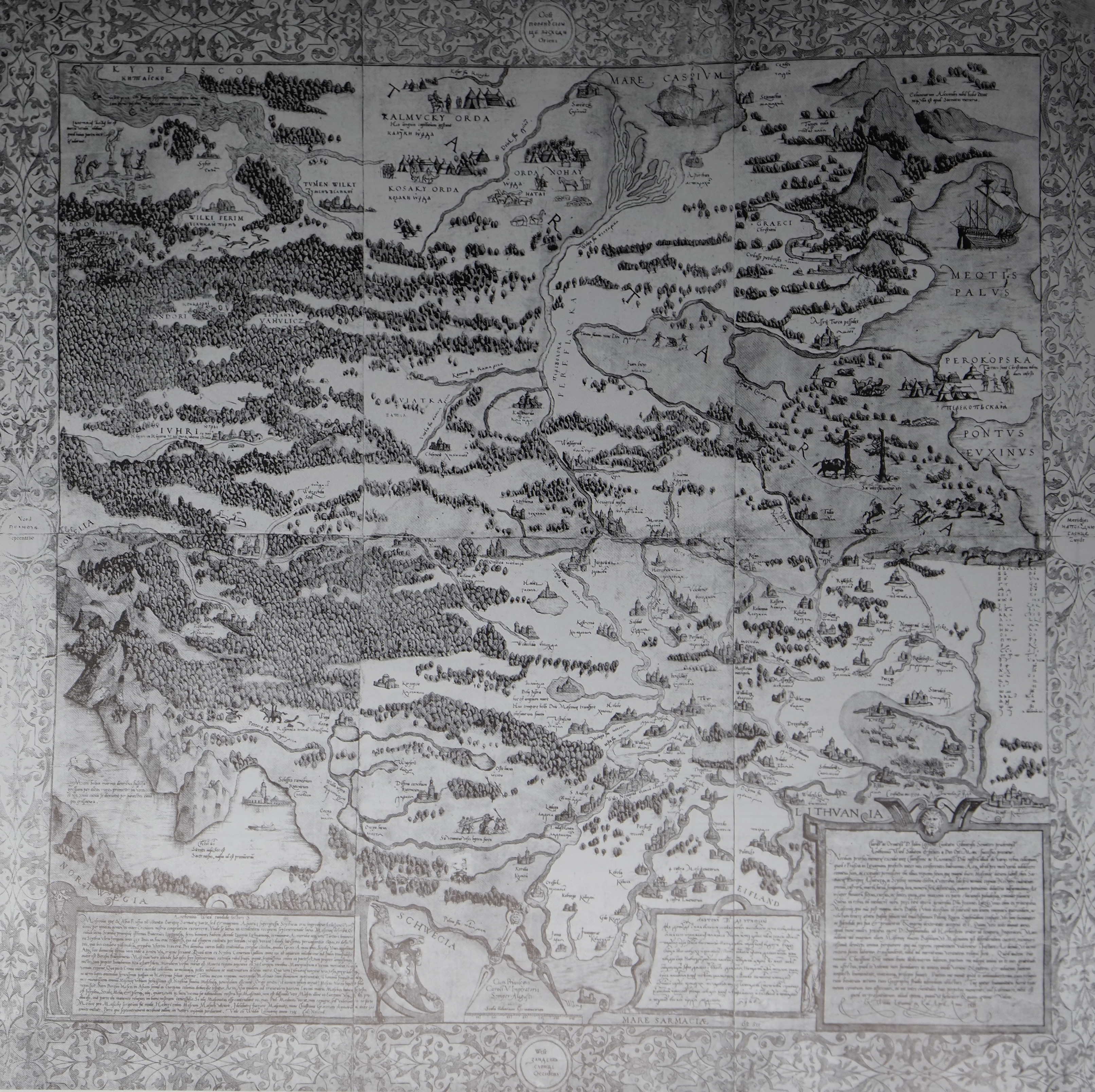
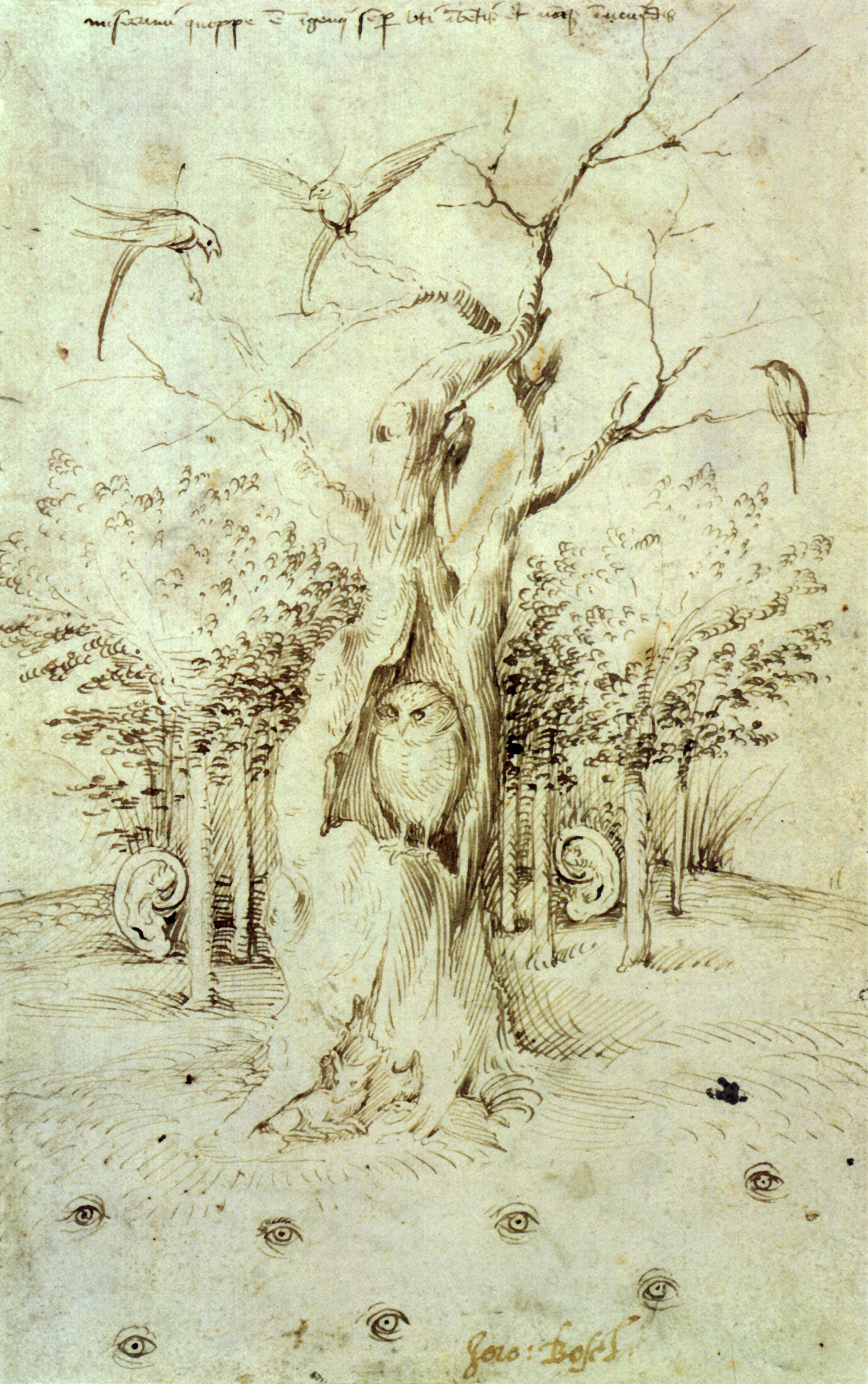
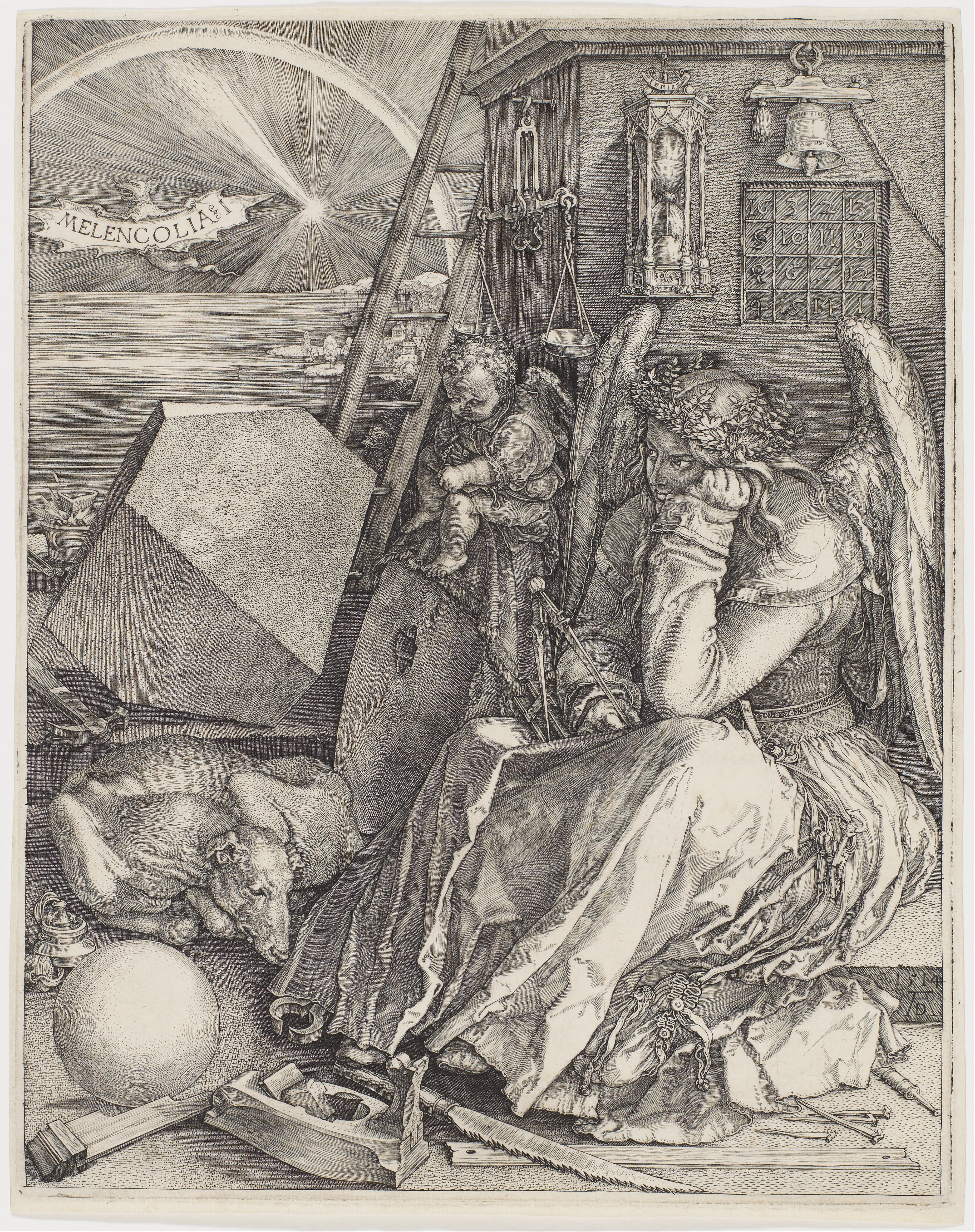
The 1570 Hogenberg engraving of the 1535 Lyatskiy / Wied transcription1 of Miechowita's “Tractatus de duabus Sarmatiis Asiana et Europiana et de contentis in eis”2[Ku17][F18][N23], focused on the latter's eastern narrative periphery—here left nameless as the only ethno-political domain (sic!) within the map's field, and presented in a state of stark civilisational alienation and indefinition (extending amorphically between the idol of the Ugro-Finnic deity①Zarni An and the many Tartar Ordes② that emerged from the decomposition of the Golden Orde). Thus, it articulates the hegemonic geopolitical and historical manifesto of the House of Gedyminas—envisaged under the ægis of the I Republic, projected from Kyiv, the Mother of All Ruthenian Cities (purposefully placed in an a-topographical position③), and sealed by the lasting totemic presentation of the Battle of Orsha④[F18]. Through Miechowita's imperial apology of Sigismundus I the Old, an implicit yet direct reference is established to the Jagiellons—regarded as heirs of Gedyminas, and hence as rightful intra-colonisers and gatherers of all Ruthenian Lands after the dissolution of the Golden Orde. The reference becomes intricately contextualised and modernised by the engraver's (?) choice of the symbolic content of the cartouche⑤, which opens an avenue to essential semiological associations with Aesopus' fable “The Owl and the Birds” (or possibly even with its important rendering due to Aesopus' avid reader Hieronymus Bosch3). It puts the Republic and its sovereign in the unique position of rare and precious first-hand knowledge of the nature of Tsarev Ulus[Hal82], i.e., of the Muscovite Khanate, and therefore also in the important rôle of a sentinel of the European œcumene. This decoding is amplified by the highly unusual semiological borrowing from Dürer, placed symmetrically relative to the cartouche with the owl-and-birds motif across the field of the map: the inimitable Bat⑥—the bearer of the title of Dürer's celebrated Melencolia I4. The sign can readily be traced back to the canonical work on the occult by Heinrich Cornelius Agrippa von Nettesheim, “De Occulta Philosophia Libri Tres”—well known to Dürer—in which the bat figures (alongside the owl) as an augural Saturnian being, sleeplessly vigilant and omen-bearing.
The partisan status of the map in the contemporary ideological discourse regarding the rapidly transforming Eastern Periphery of the European œcumene is further emphasised by the presentation—manifestly normative and strategic/persuasive, and most certainly intentionally so in view of the unquestionably high geographical competence possessed by its makers (Lyatskiy, his nameless Lithuanian companions, and Hogenberg)—of the Great Novgorod⑦, depicted greater than ever, and–importantly–greater than Moscow, already in the 1535 prototype, and further enlarged by the artist-engraver in its remake in the fateful year 1570—the year of the city's annihilation by Ivan IV the Mad. The systematic and brutal manslaughter ordered and carried out by the savage kniaź between January and February of that year, following false accusations against the city's authorities of conspiring with the Republic against Muscovy, brought the long 'democratic' (veche) tradition of the rich merchant republic to a gory end—a fact which could not have left Hogenberg, known for his outspoken engagement against tyranny5, indifferent and detached.
The map, first drawn—around 1535 [Bu36]—jointly by Ivan Vassilyevich Lyatskiy, the okolnichiy of the late khan-tsar Ivan IV the Mad (i.e., by a person responsible for, i.a., official travels of the khan-tsar and his diplomatic guests), and high commanders of the Lithuanian army [N23] with the help of Anton Wied and under the auspices of the wealthy Gdańsk bourgeoisie represented by Senator Johann Koppe, and subsequently re-engraved by one of the most accomplished cartographers and graphic artists of the Golden Age of Dutch Cartography, Frans Hogenberg on one of the then best European papers6 enjoyed a seemingly curious post-production fate: No sooner had it been (re-)published by Hogenberg than it... vanished altogether from the public view, without leaving a lasting imprint in the budding cartographic narrative of the region [Ba75]. Its apparent irrelevance was sealed by Ortelius's decision to publish—in his canonical and monumental Theatrum Orbis Terrarum—an alternative representation of the region, submitted by Anthony Jenkinson7, an English sailor and merchant endowed with an impressively rich imagination but a somewhat limited knowledge of the subject matter. Thus, on the face of it, the most knowledgeable cartographer of the epoch gave preference to an oneiric vision of a faraway country—and an important emerging market—produced by an adventureous traveller and self-made geographer (and an opportunistic admirer of the savage tyrant, whom he depicted as an exotic sage) over a detailed and professional cartographic description prepared by a highly competent insider (and a refugee, escaping the brutality of the same throne), and that in contrast to his own chief engraver—a person of great talent and experience—who deemed it worth his time and effort to re-engrave the other map with the best materials available 35 years subsequent to its creation, extending its range in the process, and dramatically enriching and deepening its semiological layer. This conundrum is readily elucidated by a tentative yet highly plausible identification of the map's agenda, and of the powerful professional client willing to pay for its production in a limited, possibly even semi-secret edition: The map was made for strictly military and trade purposes, and commissioned by the Republic at war with the Muscovite Khanate, vitally interested in gaining a tactical advantage over a numerically stronger adversary while securing or extending its trade contacts with the north-eastern region. This idea seems to be corroborated—at least in its military aspect—by a recent historical study [Ł17], in which the Lyatskiy / Wied Map is presented as the first map ever to be used by the Res-publican forces in modern warfare, and that in their confrontation with Muscovites in the course of the XVI century. In this context, it is worth noting that the map exhibits an unconventional orientation, pointing eastwards as if to indicate the direction of civilisational expansion—or of an army's advance.... Thus, in this very special cartographic text from a culturally laden spatio-temporal juncture, the various constitutive elements of the map as a cultural artefact with both abstract and practical dimensions, and as an expression of pouvoir-savoir become expressed clearly and harmoniously, and subordinated to the overarching geopolitical project.
1The prototype 1537 Lyatskiy / Wied Map from the Herzog-August-Bibliothek in Wolfenbüttel.↩
2Elements of the peculiar Miechowitian eastern-Sarmatian imaginarium present in the map: The wolverine in an unmistakably Miechowitian physiological situation⑧, and the hunted walrus⑨ (both called by their Polish names). Also the Golden Hag on the banks of the river Ob①.
↩
3The Meisterstich “Het woud heeft oren, het veld heeft ogen” by Hieronymus Bosch—an artistic translation of Aesopus' fable.
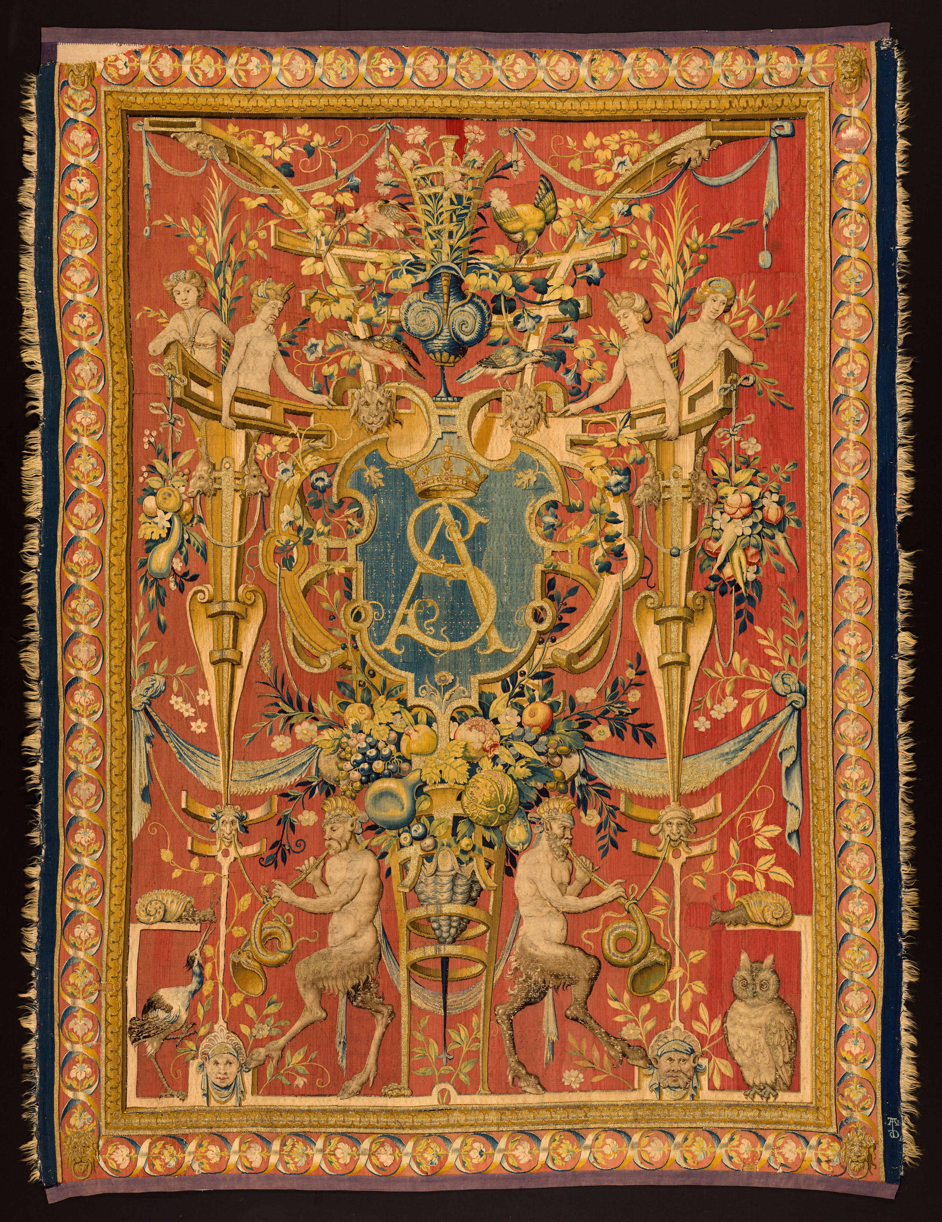
Currents of the symbolic charge of Aesopus' thought circulated widely in the European semiosphere in the XVI century, as evidenced—importantly from the point of view of the present discourse—by their verbatim appearance (note the owl-and-birds motif below!) on royal tapestries acquired for the Wawel Castle by Sigismundus II Augustus (and largely inspired, i.a., by Bosch's œuvre through its Flemish makers and artists such as Cornelis Bos).
↩
4The Meisterstich “Melencolia I” by Albrecht Dürer. The symbolism of the work, and in particular the depiction of the bat, refers directly to the canonical text on the occult by Heinrich Cornelius Agrippa von Nettesheim (who had been the first to identify and name the melancholy of type I—that of the scientific mind).
↩
5One of a series of engravings by Frans Hogenberg under the title “Spaanse Furie” documenting and condemning the brutal sackings of Dutch cities by Spanish Habsburg armies in the period 1572—1579, which accompanied a military intervention aimed at putting out the Dutch Revolt.
↩
6The watermark on the 1570 engraving, identifying the source of the paper used as the paper mill of Claude Denise from Troyes (one of the best in Europe at that time, regularly supplying, i.a., La Sorbonne), see: The Likhachev Catalogue, No. 3048.
↩
7The 1562 original of the Jenkinson Map from Biblioteka Uniwersytetu Wrocławskiego.
↩
The 1613 Hessel Gerritsz engraving of Moscow—the first realistic representation of the capital of Muscovy from the time preceding the city's demolition by the occupying Res-publican forces in 16118. This is a fairly faithful, if also inferior in its attention to architectural detail, remake of a prototype due to Szymon Jędraszewicz Śmiotański, an envoy (or spy) of Sigismundus III Vasa at the court of tsaritsa Maryna Mniszech and tsar Dimitriy I, and an official guest at their wedding in 1606 [A74]. The prototype had been drawn sometime between 1606 and 1608, during Śmiotański's incarceration in Moscow after the Shuyskiy Massacre, perpetrated in the wake of the wedding. It had subsequently been brought to the Nieśwież court of Kniaź Krzysztof Radvilla the “Orphan”, where it was rendered in the form of an artistic esquisse9 by Tomasz Makowski in 1611. In the meantime, it became—according to Alexandrowicz—the basis for the Sigismundian plan of Moscow10 engraved by Lucas Kilian in 1610, and through that intermediate representation it was transposed into Gerritsz's image [A84]. The latter was presented to the newly crowned young Muscovite khan-tsar[C59] Mikhail Fedorovitch Romanov and his boyars, and thus contributed to planting a perfect Res-publican propagandist time bomb at the very root of Muscovy's imperial narrative: Indeed, the pluralis in the official term «vstkh Moskovskikh gospodarstvakh» (which translates from Ruthenian as «all Muscovite states») in its title cartouche⑩ achieves a subtle yet unequivocal negation of the foundational δογμα of the Muscovite tsardom and westward conquest of 'all Ruthenian lands'—the unitarity of the Muscovite state (see: [Kh23] for historical evidence for the embedding of this rhetorical device in the propaganda arsenal of the Res-publican court in its ideological confrontation with Muscovy; the evidence echoes an earlier scholarly polemic between Muscovite historians: Anna L. Khoroshkevich and Karl O. Schmidt). The positive obverse of the deprecatory propagandist message was the reaffirmation of the I Republic as the rightful heir to Kyivan Rus' and the guardian of its cultural legacy and territorial patrimony, including the rogue Muscovite Khanate (see: the Lyatskiy / Wied Map).
The definitely non-Muscovite, and possibly Res-publican origin of the engraving was also independently deduced by Denis A. Khotimsky from a paleographic analysis of the вязь (the ornamental Cyryllic lettering) of the title cartouche [Kh22], which revealed the presence of a couple of concealed polonisms in the text, an incongruence of the lettering's proportions with the strict (!) contemporary Muscovite standard, and the lack of any known replication of its idiosyncratic elements in common literary use in Moscow at the time of the plan's making, likewise suggestive of a Western hand.
Of course, the documented existence of a material prototype—strikingly similar in its non-canonical form (see: the alignment with the Warszawa/Vilna—Moscow axis, towards Warszawa!) to the artefact in hand and diverging from the well-established tradition (see: Siegmund Freiherr von Herberstein's and Isaac A. Maßa's drawings below, conforming with the canonical NS orientation)—with a natural military/intelligence origin (hard to imitate or compete with in an epoch, in which—as recorded and emphasised by Isaac A. Maßa in his diaries from Muscovy—one would pay with one's head for a thwarted attempt to smuggle a plan out of the diligently guarded capital of the powerful khanate) in the portfolio of an active Res-publican propagandist with direct access to and a good professional relation with the accomplished Dutch engraver justifies a dispassionate, decisive slicing of the knot of the historical enigma with Occam’s razor, all the more so in the absence of any alternative material prototype—and in particular any Muscovite one—or its administrative trace outside the neatly tailored Muscovite historiographical narrative. On the other hand, Khotimsky's investigation forges a new line of epistemological attack against the grand lie about the Muscovite origin of Gerritsz's plan (the mythical Godunov Esquisse, 'sadly lost' without trace...), sustained for decades by dogmatic Muscovite scholars (such as Mikhail N. Tikhomirov or Sokrat A. Klepikov) as part of an effort to valorise local intellectual production and a desperate attempt to defend the notion of cultural continuity amid the collapse of political structures and the ensuing systemic turmoil during the Time of Troubles. The significance of this new approach is heightened by the pervasive reproduction of the lie and its nonchalant propagation commonly encountered—alas!—also among respected European historians (see, e.g., Günter G. Schilder's uncritical reiteration of Klepikov's feeble mental construct and astoundingly selective citations from Alexandrowicz's research, curiously missing its key conclusions, in [Sch13:p. 186]).
When seen through the prism of the interpretative scheme elaborated above, and in conjunction with the discussion of the ideological dimension of the previous cartographic text, the present one acquires the status of a logical closure of the Res-publican Eastward Intra-Colonial Triptych, grounded in Miechowita's Treatise:
The Geopolitical/Cultural Manifesto: The Lyatskiy / Wied ideological projection (and a preliminary military realisation) of Miechowita's vision between 1535 and 1570;
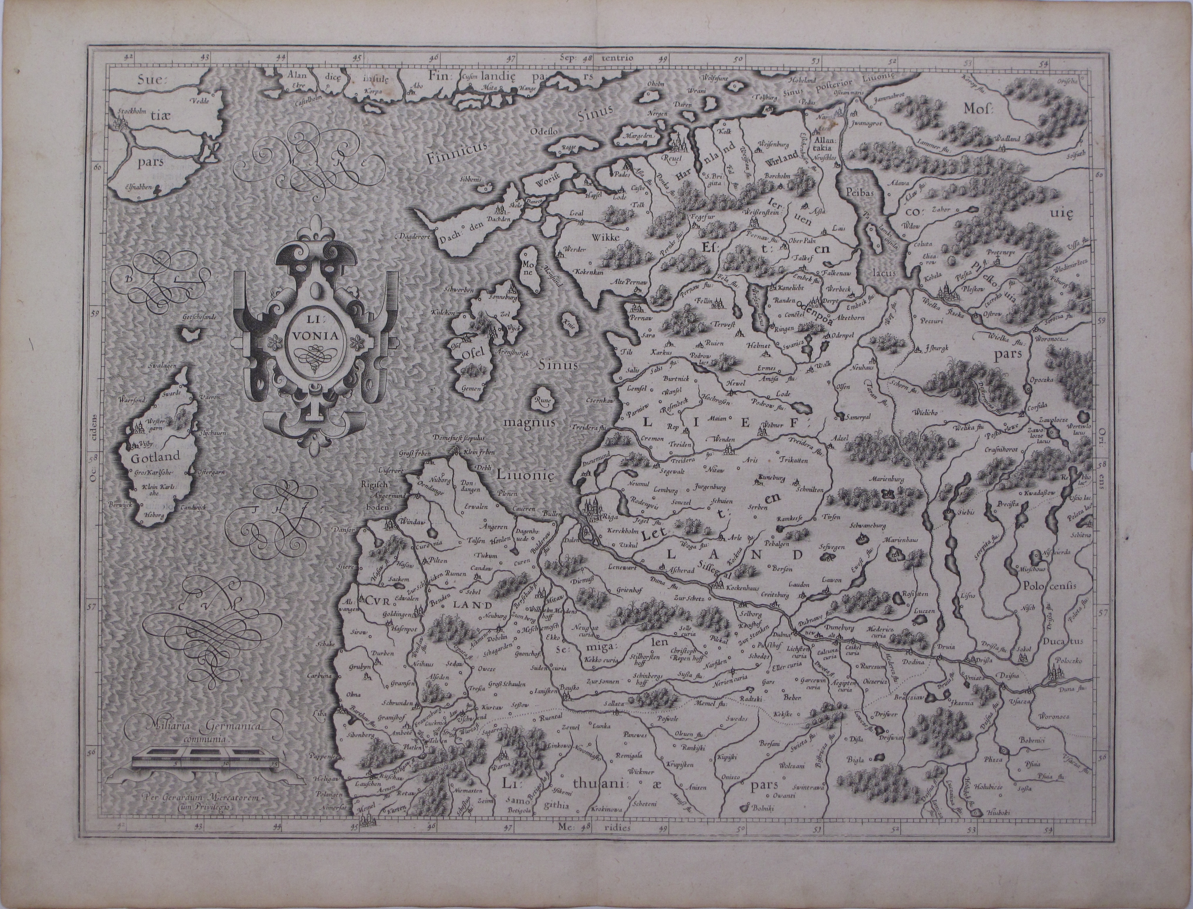
The Territorial Execution: The Strubicz résumé of the military endeavour and literary propaganda11 of the Livonian War, reproduced as Mercator's12Russia cum confinijs and Livonia (1595), and as Hondius'13Moscovia (1607) [N19].
The Administrative Crowning: The Jędraszewicz–Śmiotański / Makowski gloriette focusing the reader's attention on the severed caput of the subjugated khanate (recall: the capture and deposition of the Muscovite khan-tsar, the incarceration of his family, the humiliating defeat and subsequent placement in captivity of the highest-ranking military commanders and the patriarch of the Muscovite church; finally, the seizure and destruction of Moscow), and its Res-publican prosthetic replacement, loyal to the victorious centre of power (recall: the enthronement of Vladislaus Vasa as tsar, the garrisoning of the Muscovite Qirim-le Grad)—symbolically clasped in Kilian's heraldic resignification of the original plan through the introduction of the domineering (royal) Res-publican coat of arms (an image soon to be popularised by Braun and Hogenberg14).
Semiologically potent as revealed by the interpretation advanced above, the Res-publican image of Moscow simultaneously marks a turning point in the very narrative that it co-delineates: There has been no natural continuation of the Triptych, the Republic has not transcended its hitherto status relative to the neighbouring khanate, Muscovy has not been colonised and returned to the Kyivan patrimony; within a half-century from the moment of the publication of the Jędraszewicz–Śmiotański / Makowski Plan, the spearhead of expansion lost its edge, and was forced to turn around. One would, however, be mistaken to assume naïvely that the chapter of regional and global history it had filled with rich symbolism has since been closed... When forcibly inscribed into a definition of group identity—thus polluted and impoverished, yet at the same time rendered functional and conveniently manœuvrable—the memory of humiliation and injury endures alongside the group it helped bring into being15.
8The seizure of Moscow, which came soon after Stanisław Żółkiewski's (the Field Hetman of the Crown) spectacular victory over Muscovite forces in the Battle of Kłuszyno on July the 4th, 1610, led to the enthronement of Prince Vladislaus Vasa as tsar of Muscovy (a title that he oficially renounced only a quarter of a century later), sealed by the Shuyskiy Tribute before Sigismundus III Vasa and Vladislaus Vasa,
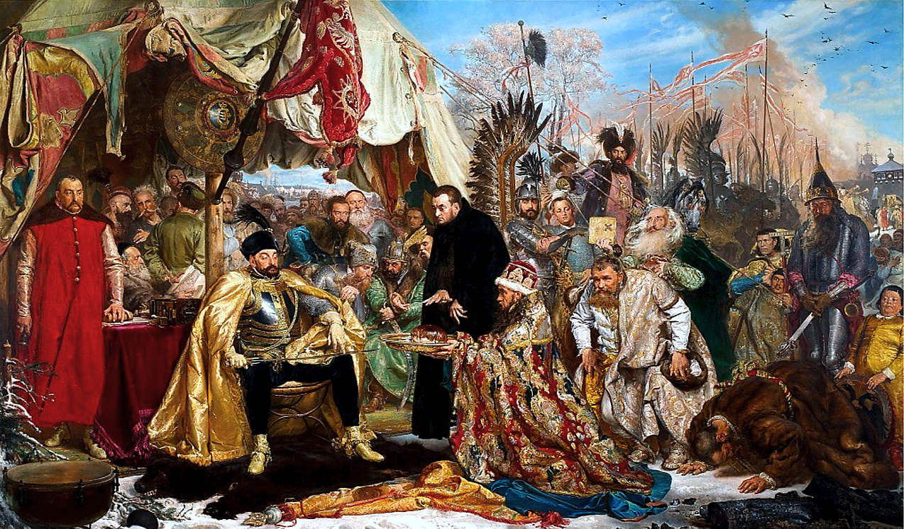
(shown here on a XIX-century bartynotype of a reproduction of one of the two magnificent paintings by Tommaso Dolabella—originally made for the king in commemoration of his triumph—which was engraved by... none other than Tomasz Makowski—see: the Strubicz / Makowski Map below), and a two-year occupation of the city by Res-publican forces from September the 21st, 1610 until October the 26th, 1612. In that time, Muscovites made several failed attempts to recapture the city. One of them, which began on March the 29th, 1611 was crushed with exceptional brutality, leading to the deaths of many thousands of the city’s inhabitants and the complete destruction by fire of most of its buildings.↩
9The Makowski esquisse from 1611
depicting the city before its destruction by fire on March the 31st, 1611, as documented by the flamboyant (sic!) cartouche (see: above). The author had, at that time and also later, a direct and good professional relation with the accomplished Dutch engraver Hessel Gerritsz (reflected in the latter's other works), as they were both involved in the bold Radvilla project of the charting of the Grand Duchy of Lithuania.
Note the peculiar non-standard orientation of the map, replicated in subsequent cartographic representations of the city, but different, i.a., from that on Isaac A. Maßa's dessin d'enfant
often quoted as the source of XVII-century depictions of the city, let alone Siegmund Freiherr von Herberstein's fantastic/standardised vision from 1549 (also canonically oriented).↩
10The Sigismundian plan of Moscow, engraved for Sigismundus III Vasa by Lucas Kilian in Augsburg in 1610,
11See, e.g.: Jan Kochanowski's panegyric „Jezda do Moskwy [...]”, focused on Krzysztof Radvilla's exploits during the Pskovian Campaign of Stephanus Báthory.↩
12The 1595 Mercator maps of Ruthenia Magna (or Russia, not to be confused with today's denotation—a result of a grand historical appropriation of unprecedented geographic proportions by the former Muscovite Khanate; an interesting and comprehensive discussion of the intricacies of the toponym's fate, embedded in the cartographic context, can be found in [F23])
and Livonia,
based largely on the military maps of the I Republic from the period of the Livonian War of 1558—1583. The maps had been drawn under the supervision of the royal cartographer Maciej Strubicz. Note, in particular, the curious inset in the bottom right corner of the former map (titled separately as Russiæ Pars Amplificata), apparently showing the proverbial middle of nowhere, and in fact providing a cartographic transcript of Jan Kochanowski's panegyric „Jezda do Moskwy [...]” (see: above), as demonstrated convincingly in [N19].↩
13The 1607 faithful cartographic transcript of Jan Kochanowski's „Jezda do Moskwy [...]” by Hondius: Moscovia[N19].↩
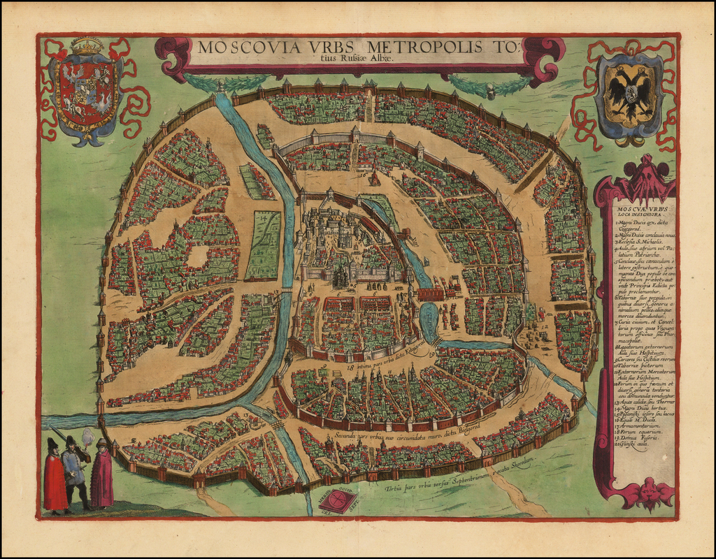
14The 1617 Braun—Hogenberg presentation of the Res-publican Moscovia Urbs Metropolis Totius Russia Albae in their celebrated Civitatus Orbis Theatrum.↩
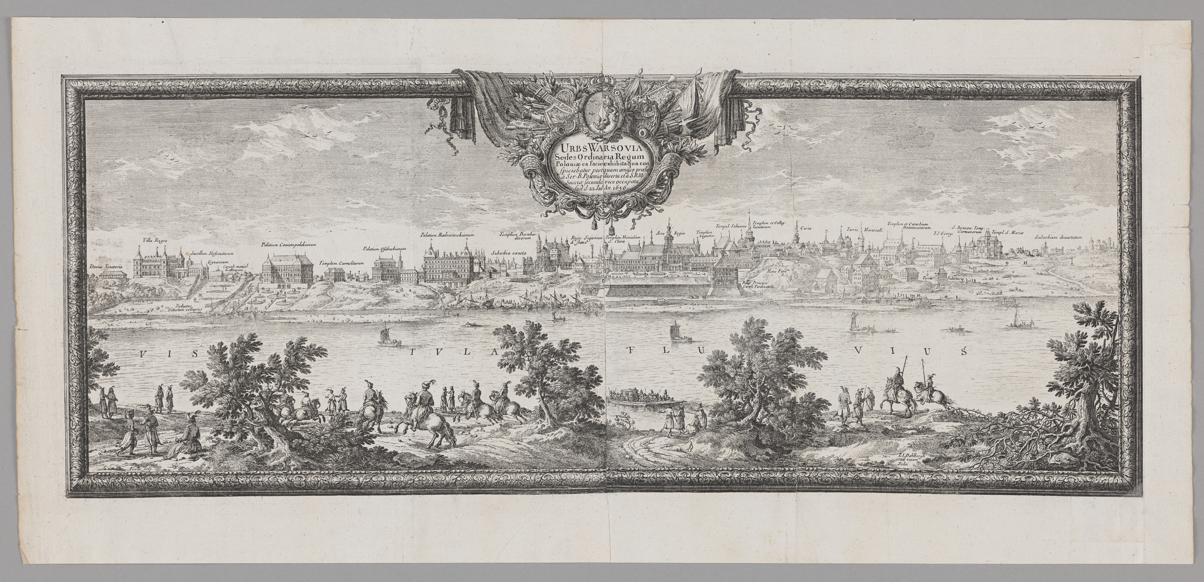
15The Muscovite authorities never cured themselves of the sickly and vile obsession to remove completely and permanently from the Res-publican collective consciousness the image of the defeated and humiliated tsar. Throughout the entire XVII century, they stubbornly—on various diplomatic ocassions— pressed the demand that the commemorative traces of the events of 1610—perceived as offensive to Muscovite pride—be withdrawn from the official and public semiosphere of the Republic and that all material evidence of the imprisonment of the tsar’s family in its capital be erased. In particular, they requested that Dolabella’s paintings of the Shuyskiy Tribute be removed from the walls of the Royal Castle and handed over to them, and that the Muscovite Chapel in Warszawa, the burial place of the family of the dethroned tsar
(Sacellum Moscovitarum, the third marked building from the left on the 1656 engraving by Erik Jönsson Dahlbergh), be demolished. Their efforts were eventually crowned first by a forced acquisition or a blatant looting of Dolabella’s paintings at the beginning of the XVIII century (it is not certain which of the two took place), and later by the devastation of the original architecture of the Staszic Palace (on whose grounds fragments of the Chapel had allegedly been discovered) and its premeditated reconstruction in a crude Muscovite style. Rediscovered once again among the old buildings of Warszawa in the interbellum period 1918—1939, the structure was prepared for symbolic reconstruction—an undertaking, however, prevented by the outbreak of the war. After the war, the ruins identified as the remains of the Muscovite Chapel were dismantled by an administrative decision of the communist authorities of the People's Republic of Poland, a puppet state of the Soviet Union—the post-(bolshevik-)revolution reincarnation of the imperial Muscovite spirit, as late as 1954. Half a century later, in 2004, the Russian Federation—the cultural chimæra which amalgamated the seemingly incongruent heritage of the Soviet Union with that of the Muscovite Khanate-Tsarate—replaced—at the initiative of Vladimir Surkov (!), one of the leading ideologues associated with Moscow’s neo-imperial policy— the main gosudarstvienniy prazdnik (i.e., a state holiday) of the former (The Day of the Great October Socialist Revolution, instituted by khan-gensek Yossif Vissarionovich Dzhugashvilli “Stalin” in 1927, and celebrated officially until 1990) with a new-old holiday of the latter (The Day of Moscow’s Liberation from Polish Invaders, first instituted by khan-tsar Mikhail Fedorovitch Romanov in 1613, and celebrated until 1917)—The Day of National Unity, commemorating the 1612 liberation of Moscow from the Polish–Lithuanian occupants...↩
Literature
Historical/Critical/Semiological discussion:
[A74]
[A84]
[A12:pp. 183—186]
[AŁS13:pp. 20—21]
[C59]
[Kh22]
[Kh23]
[Sch13:pp. 186—194] (an erroneous identification of the plan's prototype)
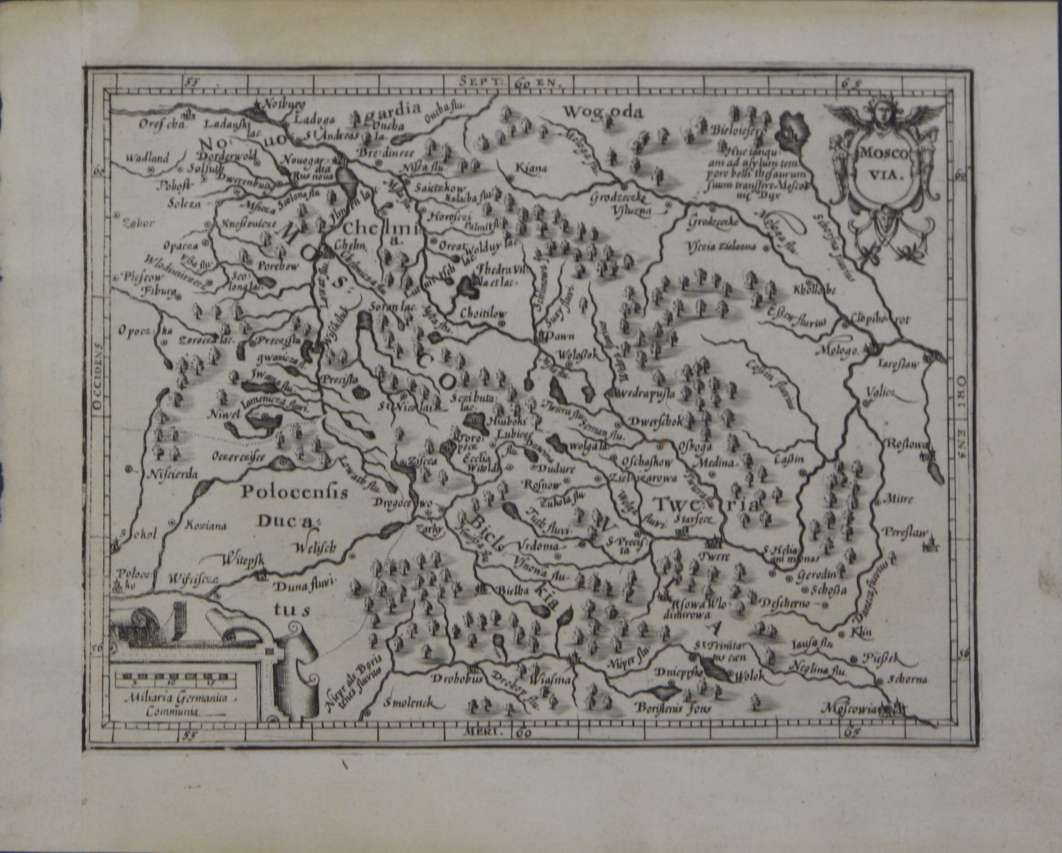
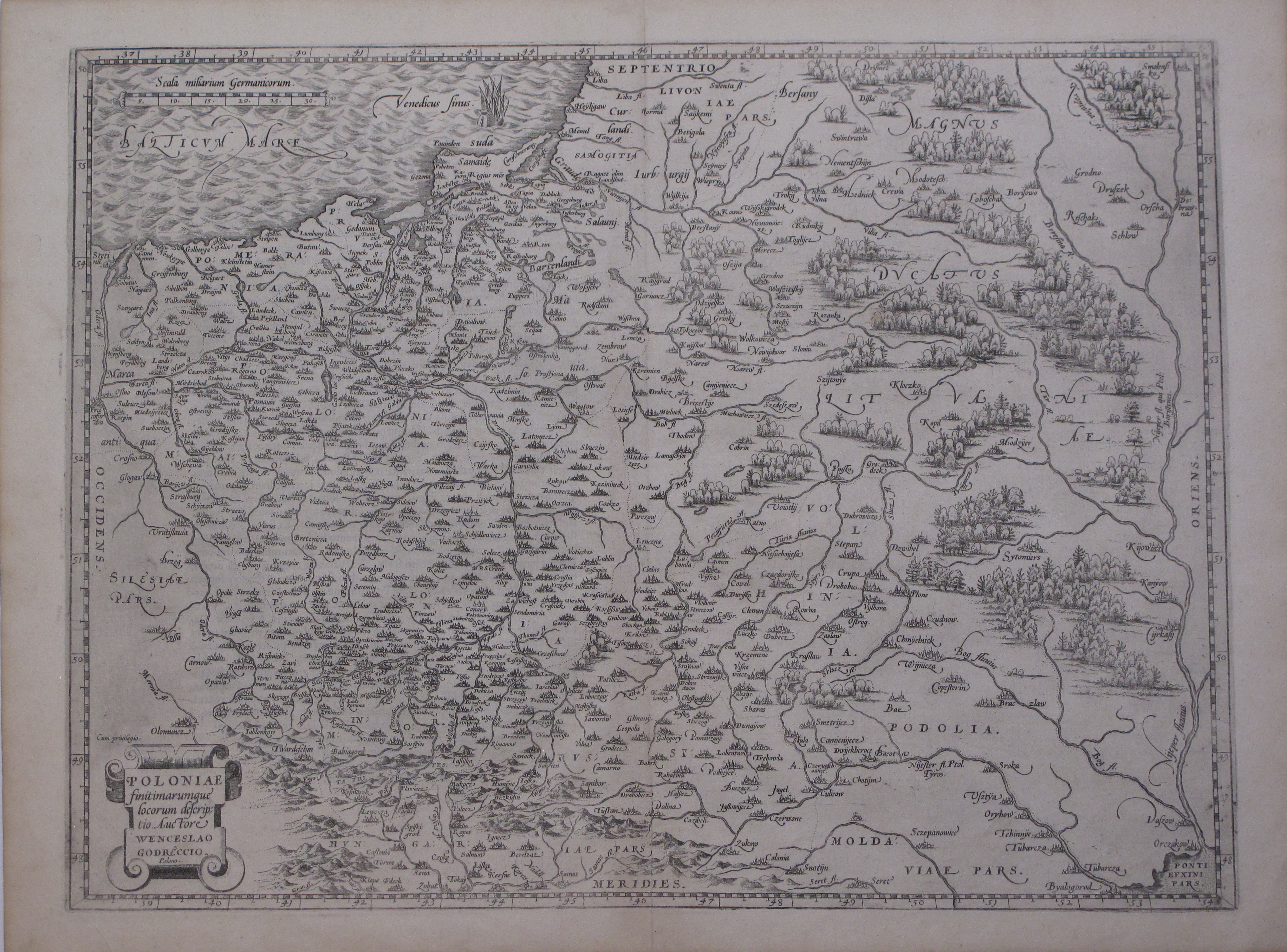
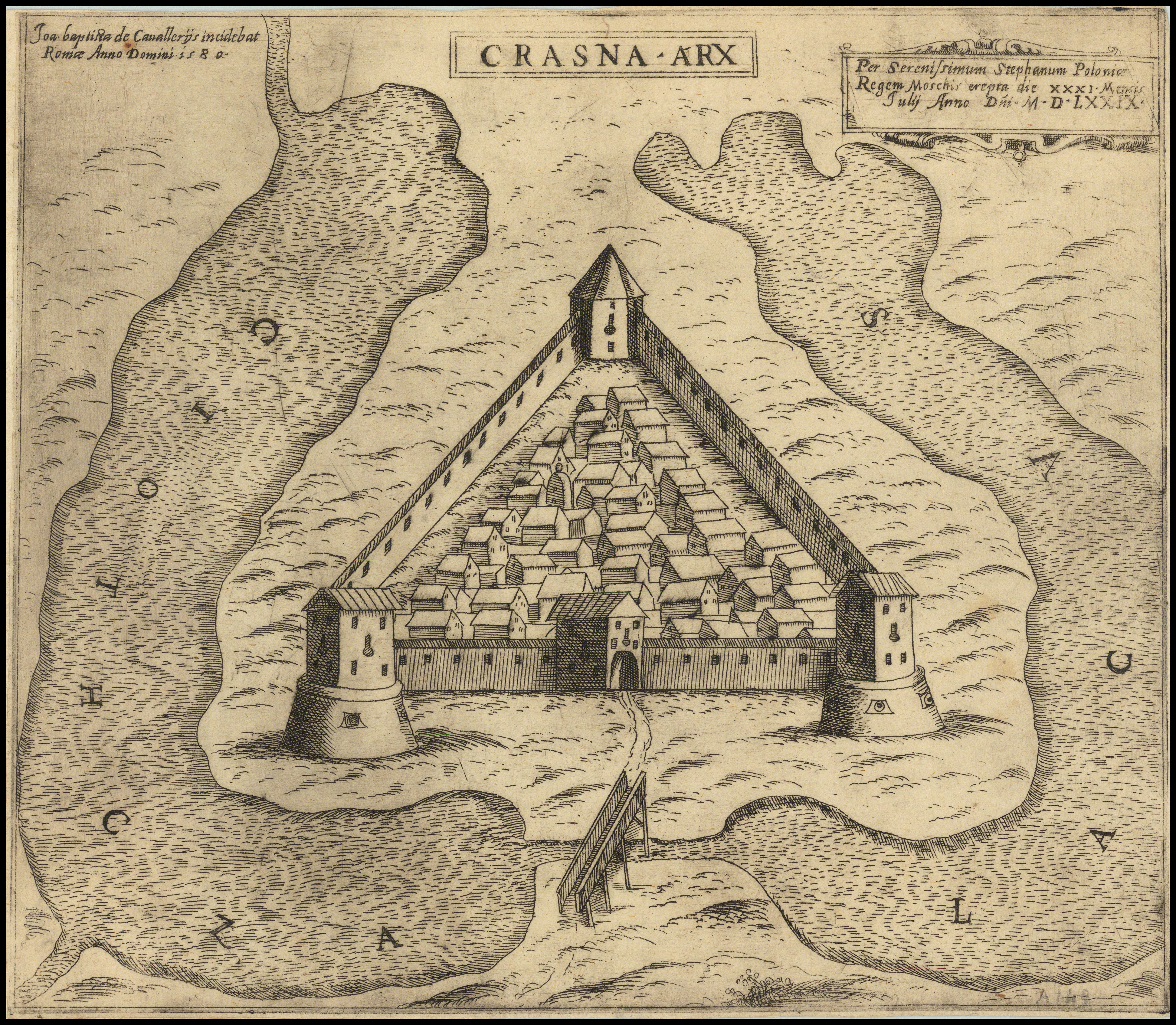
The 1631-38 state16 of Hessel Gerritsz's 1613 engraving based on cartographic materials prepared and gathered, in the last decade of the XVI century17, by Maciej Strubicz, the court cartographer of Sigismundus II Augustus and Stephanus Báthory, and by Tomasz Makowski, a talented graphic artist appointed at the court of Kniaź Krzysztof Radvilla the “Orphan”. The map establishes Nieśwież—the culturally vibrant courtly milieu of the Radvilla Family, where it was drawn—as an umbilicus mundi⑪. It is rather spectacularly focused on the Grand Duchy, and—at the same time—ostentatiously dismissive of the cultural substance of the post-Lublin-Union (!) Crown. As such, it enters into a rather bemusing frictional dialogue with the 1562 Grodziecki map of the I Republic18, in which the mirror-symmetric cultural-political logic had been articulated. The map also exhibits—in a most clear-cut, amply documented and hence convincing manner—the fundamental ontological difference between the two state borders of the I Republic in the latitudinal direction: the Western limen, and the Eastern limes. The latter, separating the Republic from Imperium Chami, i.e., the Orde, is lined up with numerous representations of battles with Muscovites and Tatars⑫⑬⑭⑮, fought by Sigismundus I the Old, Sigismundus II Augustus and Stephanus Báthory, and—i.a.—portrays very vividly and evocatively the devastation of Ivan IV the Mad's fortresses in the Principality of Polotsk—such as, e.g., the Krasne Castle19⑫—seized and destroyed by Res-publican forces on their way towards Polotsk in the course of the victorious Báthorian campaign of 1579. The campaign had played the rôle of the factual substrate for the first regional atlas of the I Republic—the Pachołowiecki Atlas, engraved by Giovanni Battista Cavalieri and distributed—as part of a wider propagandist action—in Rome, right under the pope's nose, and in the rest of Europe in 1580 [NŁF25].
The map is the first official text ever to use the denotation «Ukraina»⑯ in the Western (Latin) semiosphere20. It also features a very detailed account—both verbal⑰ and cartographic—of the Zaporizhian Sitch⑱, with its many Cossack island settlements southwards of the Porohy⑲.
18The first (1570) state of the Ortelius' engraving of the canonical map of the I Republic drawn by Wacław Grodziecki during his academic sojourn in Leipzig. The astoundingly precise and beautifully detailed cartographic text defined the image of the Republic in the European semiosphere for the next ca. 100 years, replacing the previous standard candle by Bernard Wapowski, which had... burned quite literally in the Great Fire of Kraków in 1528.↩
19The majestic Krasne Castle—in reality, a primitive Muscovite stronghold with ca. 100 m-long wood-and-clay ramparts—sitting at the junction of and thus controlling the logistical routes of the invading Res-publican army and of the pivotal (and more powerful) Muscovite Susza Castle, which was paralysed by the capture of Krasne on July the 31st, 1579, and subsequently surrendered on October the 6th, 1579.
Notably, Jan Zamoyski, the Grand Chancellor of the Crown and counsellor to Stephanus Báthory at the time of the Polotsk Campaign, rejoiced enthusiastically at the capture of the Krasne Castle in his letter to Nuncio Caligari on August the 4th, 1579, see: [Zam1579].↩
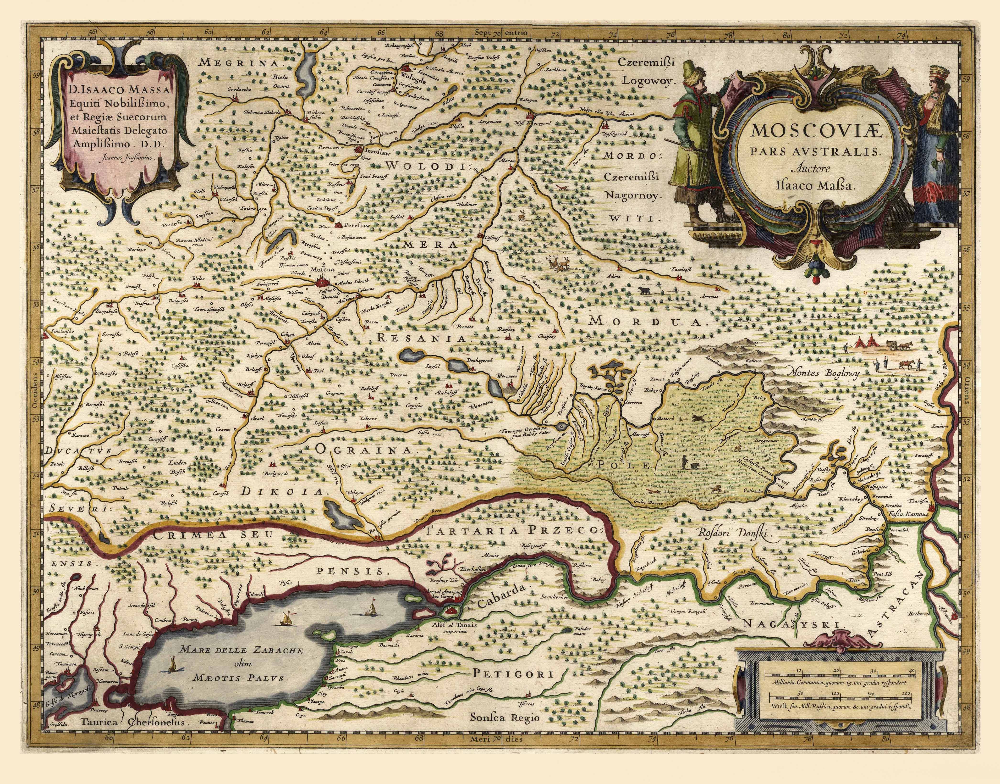
20Needless to say, the denotation had appeared much earlier in the Eastern (Cyryllic) semiosphere, to wit: in Київський літопис (the Kyivan Litopys), published in Kyiv in 1187. And no, there is no reason to despair—as Muscovite propagandists do—over the opening «O» in the Cyryllic «Оукраїна» (allegedly—and falsely—identifying Ukraine with the Muscovite «Okraina», as seen in Isaac A. Maßa's (counter-)map, engraved by Jan Janszoon in 1636,
a safe distance away from Ukraine across the contested territory of the Principality of Novogrod Severskiy—just as there is no reason to despair over the opening «O» in the Greek «Οὐρανία»—if one understands the source of the code introduced by Cyril and Methodius in an attempt to grapple with the Eastern Slavic languages...↩
Staphanus Báthory at Pskov (alongside Jan Zamoyski, Stanisław Żółkiewski et al.)
...TO BE CONTINUED, USQUE AD FINEM...
Acknowledgements
The Author's quest of the rich cartographic residue of the I Republic would not be possible—in any one of its many dimensions— if it were not for the unwavering and unlimited spiritual and material support from the Hallay–Suszek Family, grounded in a profound understanding of the intellectual value of a study thus oriented. In particular, the active rôle of Jadwiga Suszek, the Author's Mother, and Her dedication to the cause has always been critical for the constant evolution and financial security of the research.
The Author also expresses his deepest gratitude to and cordial sympathy for Barry L. Ruderman who—through his multifarious support, driven invariably by a shared passion and comprehension of maps, and the kind of sensitivity that distinguishes Map Readers among collectors and antiquarians alike—has contributed decisively to the creation of unique conditions under which the study of cartographic texts about the Republic and its wide œcumene could become not merely an intellectual pursuit, but a direct experience, and hence also a genuine delight to the mind and spirit.
He is indebted to Grzegorz Franczak and Tomasz Kempa for kindly and generously sharing with Him their expert knowledge—and even some unpublished findings (G.F.)—about the Res-publican ghost-mapping of the Eastern Periphery. Denis A. Khotimsky's perseverence, originality and methodological versatility in grappling with the Grand Muscovite Carto-Historical Lie in the context of the early mapping of Muscovy is recognised with distinction, and his willingness to share his many and various insights is greatly appreciated. The Author also acknowledges numerous interesting exchanges with Stefano Bifolco, Filip Devroe, and Clemens Paulusch about the cartographic heritage of the Republic and its current distribution on the global antiquarian market, as well as the intricacies of the cartographic craftsmanship of the Golden Age.
Very special tribute is owed to Michał Wojcieszczuk, whose engagement in this carto-apocrypholytic undertaking transcends the ordinary bounds of shared cultural and scholarly curiosity, the comradeship of struggle for historical truth against historical falsehood, and a singular affection for the cartographic idiom. And while no less is to be expected of a Person, for whom—as for the Author, and not without an intimate and well-documented causal link—the complex semiology of the space so provocatively dubbed public has—along the intersection of the respective knotted worldlines—become much more than an abstract, neatly axiomatised concept, the convincing transit from the obvious propensity to the much less obvious actuality renders the Author deeply grateful.
Literature
References point to and are to be consulted with the Carto-bibliography.
This site is currently under construction, and its content—while already thought-provoking—is far from the envisaged state of completion, which shall, one day, provide—it is hoped—a foundation for more abstract, global inferences.

 Retro
Retro